Geology of the Wetmore Area Wayne I. Anderson |
|
Introduction The geologic history of the east flank of the Wet Mountains, described previously in “Traverse Along South Hardscrabble Creek: A Trip Through Time,” provides an appropriate introduction to “Geology of the Wetmore Area”, so I’ll not repeat all of those details here. This section will emphasize aspects of the geologic history of the Wetmore area that were not covered elsewhere.
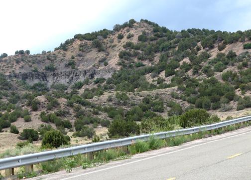
Bedrock Geology Exposures of bedrock along Highway 96 southwest of Wetmore provide impressive views of the Precambrian basement rocks of the area. The San Isabel “Granite” is a coarsely- crystalline igneous body that intruded older Precambrian metamorphic rocks. The San Isabel “Granite” is 1.4-1.5 billion years old and is classified as quartz monzonite, a close relative of granite. The banded metamorphic rock called gneiss forms the core of the Wet Mountains and is approximately 1.7 billion years old. Gneisses of the Wet Mountains probably formed by metamorphism of ancient sedimentary strata and layered volcanic rocks. |
|
 |
||
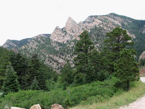
Lover's Leap in Hardscrabble Canyon, southwest of Wetmore, is underlain by resistant Precambrian igneous and metamorphic rocks. |
||
Dark-colored dikes of Cambrian age intrude the Precambrian basement rocks along Middle Hardscrabble Creek, southwest of Wetmore. Lower and Middle Paleozoic sedimentary strata are not exposed near Wetmore, but the nonmarine Pennsylvanian-Permian Fountain Formation is prominently exposed along the crest of Red Anticline (arch-like fold) that trends northeastward in the Mason Gulch area, southeast of the village of Greenwood. The Jurassic Morrison and Ralston Creek formations are also revealed southeast of Greenwood. |
|
 |
||
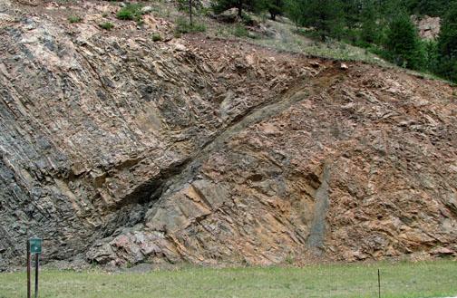
A dark-colored dike, probably of Cambrian Age, cuts across banded Precambrian gneisses in Hardscrabble Canyon, southwest of Wetmore. |
||
Resistant sandstones of the Dakota and Purgatoire formations form impressive hogbacks along the flanks of Hardscrabble Syncline (trough-like fold) and Red Anticline, south and southwest of Greenwood. These exposures can be seen along Highway 96. Hogbacks are long, narrow sharp-crested ridges that are resistant to erosion. The Wetmore area is home to some textbook examples of these linear landforms. The Cretaceous Dakota and Purgatoire formations also form a conspicuous hogback in the vicinity of South Hardscrabble Creek. |
|
 |
||
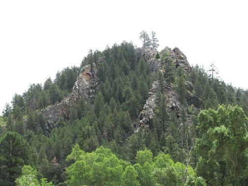
Erosion of folded Dakota and Purgatoire formations has produced a prominent hogback along Highway 96 near Greenwood. |
||
Additional Cretaceous formations are exposed near Wetmore. These formations include (oldest to youngest): Graneros Shale, Greenhorn Limestone, Carlile Shale, Niobrara Formation, and Pierre Shale. All of these formations are of marine origin, the products of deposition of lime and mud in a shallow marine seaway. Fossils of ancient clams and cephalopods occur in these rocks. In addition, the Pierre Shale contains thin layers of bentonite (altered volcanic ash). Tertiary volcanic rocks (25 to 30 million years old) crop out along the margins of the Wet Mountain Valley graben in several places. For example, small volcanic fields occur on the east flank of the Wet Mountain Valley near Silver Cliff, Rosita, and Deer Park. Andesite and other volcanic rocks occur in the Greenhorn Mountain area of the southern Wet Mountains. However, no Tertiary volcanic rocks are exposed in the vicinity of Wetmore. |
|
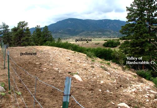
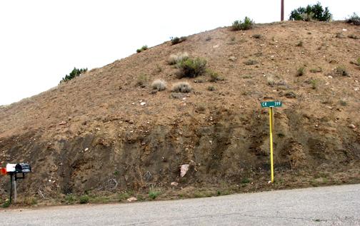
Surficial Geology The Wetmore area has a significant record of surficial (unconsolidated) deposits of Quaternary age (approximately the last 2 million years of geologic time). The Quaternary record is represented by deposits of the Pleistocene Ice Age and the Holocene (Recent). The Holocene, or Recent, represents the last 10,000 years of geologic time. Multiple episodes of glaciation and deglaciation occurred in the towering Sangre de Cristo Range during Pleistocene time. No glacial deposits have been recognized in the Wet Mountains, probably because they were too low in elevation for glacial ice to accumulate. However, the landscape near Wetmore was modified significantly during Pleistocene and Recent times. Running water from melting snow and ice and from increased precipitation cut extensive erosion surfaces and deposited thick layers of coarse alluvium. Climate fluctuations triggered increased erosion and down cutting by streams, stranding former erosion surfaces when streams cut down to lower levels. These alluvium-capped erosion surfaces are called pediments or terraces, depending on their setting. Pediments are broad, gently-sloping, rock-floored erosion surfaces. They have low relief and typically develop by running water at the base of a receding mountain front. Pediments are usually mantled with a covering of alluvial sediment derived from the adjacent mountains. Pediments are similar to stream terraces except they are not confined to well-defined valleys. At the present time, the Quaternary surfaces and alluvial deposits of the Wetmore area are undergoing dissection and erosion by processes at work in today’s landscape. Taylor and Scott (1973) recognized seven mappable bodies of alluvium in their Geologic Map of the Wetmore Quadrangle. These alluvial units are described below in order of age, oldest to youngest. Nussbaum Alluvium: The Pleistocene-age Nussbaum Alluvium is boulder-bearing alluvium. It is crudely stratified (layered) and poorly-sorted (wide range of sizes of materials). It is about 80 feet thick and lies on pediment surfaces about 320-360 feet above present streams. Rocky Flats Alluvium: This early Ice-Age deposit is poorly stratified and poorly sorted; it consists of boulder-bearing alluvium. About 20 feet thick, the Rocky Flats Alluvium is found on pediments about 350 feet above modern streams. Verdos Alluvium: The Pleistocene Verdos Alluvium is poorly-sorted, stony and sandy alluvium. It is about 20 feet thick and occurs 60-70 feet above modern streams. The stones in the Verdos Alluvium are highly weathered and often coated with lime (calcium carbonate). This unit is a possible source of gravel. Slocum Alluvium: The Slocum is middle Pleistocene in age and poorly stratified. It contains clasts ranging in size from pebbles to boulders. A possible source of gravel, this unit is approximately 20 feet thick and lies on pediments 50-120 feet above modern streams. Louviers Alluvium: The late Pleistocene Louviers Alluvium is pebbly, stratified alluvium. About 15 feet thick, this deposit is reddish-brown in color because it was derived from the reddish-brown Fountain Formation. The Louviers Alluvium is found on terraces about 60 feet above modern streams. It is a possible source for gravel. Broadway Alluvium: The late Pleistocene Broadway Alluvium is well stratified and contains cobbles and boulders. Ranging in thickness from 10-20 feet, the Broadway Alluvium lies on terraces about 40 feet above present-day streams. It is a suitable source for coarse gravel. Piney Creek Alluvium: The Piney Creek Alluvium is Holocene (Recent) in age, the youngest of the mappable alluvial units in the Wetmore area. It is humus rich, poorly stratified, and high in silt and clay along Richie Gulch. Along Hardscrabble Creek, the unit is fairly-well stratified, sandy silt with layers of stones. The Piney Creek Alluvium is about 15 feet thick and rests on terraces about 10 feet above modern streams. |
|
 |
||
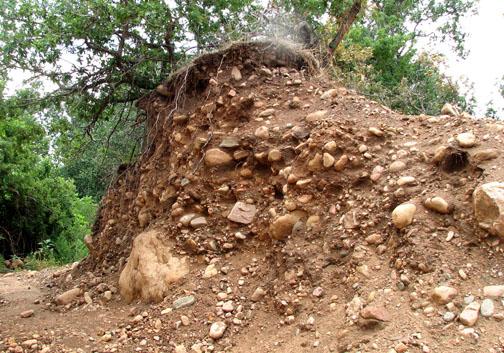
Boulder-bearing alluvium from the Pleistocene Ice Age, near Wetmore Baptist Church. |
||
 |
||
Stony and sandy alluvium (Verdos Alluvium) caps pediments 60-70 feet above the level of Hardscrabble Creek, north of Wetmore. The Verdos Alluvium was deposited by running water during the Pleistocene Ice Age. |
||
 |
||
Exposures of gray Pierre Shale at Jackson Hill about three miles east of Wetmore on Highway 96. Brown-colored Rocky Flats Allluvium overlies the Pierre Shale at this locality. |
||
 |
||
Brown-colored Rocky Flats Alluvium of early Pleistocene age caps the Pierre Shale east of Wetmore and protects it from erosion. |
||
Summary Overall, the Quaternary sediments and surfaces near Wetmore provide an intriguing record of erosion, deposition, and climate fluctuation. The bedrock geology of the region is fascinating as well. The Wetmore area boasts remarkable exposures of ancient igneous and metamorphic rocks and excellent views of both marine and nonmarine strata. Folded and tilted sandstone formations produce classic hogback ridges. Located at the interface of the mountains and the plains, the Wetmore area reveals a remarkable record of the geologic past.
Reference Taylor, R.B., and G.R. Scott. 1973. Reconnaissance Geologic Map of the Wetmore Quadrangle, Custer and Pueblo Counties, Colorado. Miscellaneous Field Studies Map MF-548, Wetmore Quadrangle, Colorado. U.S. Geological Survey. |
|
 |
 |
 |
||||