Geology and Water |
||
Wayne I. Anderson |
||
Introduction |
||
This summary is based primarily on “Ground Water in Colorado - A Primer” and “Ground Water Resources in Time of Drought” published in the October issue of ROCKTALK, Colorado Geological Survey. In addition, a section of the article was adapted from the Newsletter of the Sangre de Cristo Mountain Council, fall 2002. In the 1990s, Colorado added a million persons to its population, growing from 3.3 million to 4.3 million. This phenomenal growth and the continued popularity of the State as a major tourist destination have focused attention of Colorado’s citizens on the long term water needs of the State. Is it realistic to encourage continued growth in the Front Range corridor and elsewhere in Colorado if water supplies are limited? So far few public officials have said no to continued growth and to business as usual. Surface water provides the bulk of Colorado’s water supply, but accelerated urban growth continues to put pressure on this critical water source. There are limited opportunities to expand and develop additional storage sites for surface water. Ground-water resources presently supply about 18 percent of Colorado’s water needs, and 19 of the State’s 63 counties are entirely dependent on ground water for potable supplies and domestic uses. Agriculture in Colorado relies heavily on ground water, particularly in the San Luis Valley and on the eastern plains. About 90 percent of ground-water withdrawals in Colorado are agriculturally related. Although ground water is a renewable resource, it is not always available in the quantity needed, particularly in periods of drought. Therefore, wise water-management practices and enlightened conservation practices are needed as the State plans for the future.
Occurrence of Ground Water
Ground water is defined as water beneath the surface of the earth. In contrast, surface water occurs on the earth’s surface in streams, rivers, lakes, and reservoirs. The primary source of ground water is precipitation from rain, snow, and hail. About 81 percent of the precipitation that falls in Colorado returns to the atmosphere through evaporation and transpiration. Precipitation that does not immediately evaporate or flow directly to streams or lakes enters the subsurface through infiltration. Ground water commonly occurs as water that fills pore spaces between mineral or rock grains in sediments and sedimentary rocks. Ground water also exists in cracks and fractures in crystalline rocks such as granite or limestone. These water-filled spaces constitute the zone of saturation, the top of which is called the water table. Humans have tapped the zone of saturation for their water needs since the dawn of civilization. See following diagrams that show a variety of ground water situations. |
|
 |
||
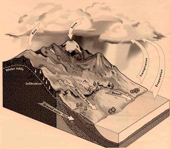
Schematic representation of the hydrologic cycle in a mountainous setting such as the Sangre de Cristo Range or the Wet Mountains. Adapted from Colorado Geological Survey ROCKTALK (2002). |
||
 |
||
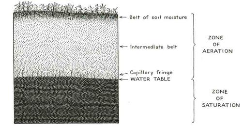
Underground water is divided into two major zones: the zone of aeration and the zone of saturation. The water table marks the upper surface of the zone of saturation. Within the zone of aeration is a belt of soil moisture from which plants draw their moisture. Adapted from Leet and Judson (1959). |
||
 |
||
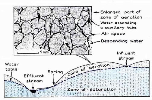
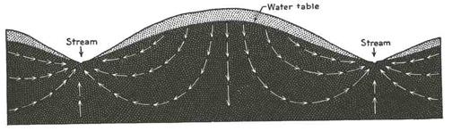
Cross section showing the water table and its relationship to streams and a spring. The enlarged inset diagram shows movement of water (black) in the zone of aeration. An effluent stream receives water from the zone of saturation; its channel lies below the water table. Effluent streams generally flow throughout the year, unless there is a severe drought. An influent stream contributes water to the zone of saturation; its channel lies above the water table. Grape Creek and Texas Creek are local examples of effluent streams. Dry Creek and Goat Creek on the east flank of the Sangres often behave as influent streams and are dry by mid-to-late summer. Adapted from Gilluly, Waters, and Woodford (1959). |
||
 |
||
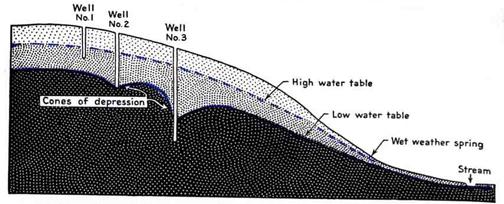
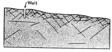
To provide a reliable source of water, a well must penetrate below the zone of saturation. In the above diagram, Well No. 1 reaches only deep enough to tap ground water during wet conditions, when the water table is high. A seasonal drop in the water table will cause Well No. 1 to go dry. Well No. 2 reaches below the water table, but continued pumping may produce a cone of depression, reducing effective flow. Well No. 3 is deep enough to produce reliable amounts of water under most conditions. Adapted from Leet and Judson (1959). |
||
 |
||
The flow of ground water through uniformly-permeable material is diagramed above, after M. King Hubbert’s model. Water movement is not primarily along the water table, but rather along broadly-looping paths. Ground water discharges into the channels of effluent streams and contributes to their base flow. Adapted from Leet and Judson (1959). |
||
 |
||
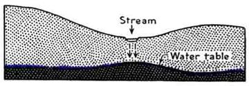
The ground water in the zone of saturation may be recharged by water leaking from a surface stream into the underground. This is the general case for an influent stream. Adapted from Leet and Judson (1959). |
||
An aquifer is a ground-water reservoir composed of sediment or rock that is saturated with water and sufficiently permeable to yield water to wells. The size of the pores and the degree of interconnections of pore openings determine an aquifer’s permeability. Permeability is defined as a material’s ability to transmit fluid. Some of the most productive aquifers in the State are unconsolidated sand-and-gravel deposits with lots of interconnected pore space. Cavernous limestones with connected solution openings also yield water readily. Unconsolidated sands or gravels often exceed 40 percent in porosity. Such sediments have the capacity to store huge volumes of ground water. Aquifers transmit ground water from areas of recharge to areas of discharge. They also store significant quantities of high-quality ground water. Unconsolidated sand-and-gravel deposits are important aquifers in the Wet Mountain Valley and occur along the flanks of the Sangre de Cristo Mountains. Fractured igneous and metamorphic bedrock are key aquifers in the Wet Mountains. In addition, sandstone aquifers occur locally near Wetmore and elsewhere along the east flank of the Wet Mountains. Some typical aquifers are illustrated below. |
|
 |
||||
Well-sorted sedimentary material. Local examples: Quaternary and Recent alluvium, sandstones of the Dakota and Purgatoire formations. Adapted from Colorado Geological Survey ROCKTALK (2002). |
||||
 |
Poorly-sorted sedimentary material. Local examples: Pleistocene outwash deposits, some Quaternary alluvial deposits, some Paleozoic sandstones and conglomerates, and Tertiary basin fill sediments. Adapted from Colorado Geological Survey ROCKTALK (2002). |
|||
 |
Fractured igneous and metamorphic rocks. Local examples: Precambrian igneous and metamorphic basement rocks of the Wet Mountains, some fractured and jointed Tertiary igneous rocks. Adapted from Colorado Geological Survey ROCKTALK (2002). |
|||
 |
Soluble rock-forming material such as limestone. Local examples: marine limestones of the Minturn Formation on Marble Mountain and elsewhere in the Sangres. Adapted from Colorado Geological Survey ROCKTALK (2002). |
|||
 |
||
Impermeable igneous and metamorphic rocks may yield water in wells if the rocks are sufficiently fractured. The water supply may be limited if the size and number of fractures decrease with depth. Also, the fractures may be poorly connected, limiting yields. Precambrian igneous and metamorphic rocks serve as local aquifers in the Wet Mountains. Adapted from Leet and Judson (1959). |
||
Aquifers that are not completely saturated with water are called unconfined aquifers. Such aquifers release water to wells by draining the pores and fractures of the partially-saturated sediments or rocks that surround the well. Unconfined aquifers are recharged by ground water that infiltrates through the unsaturated zone immediately above the water table. This zone is also known as the zone of aeration. Confined (artesian) aquifers are saturated permeable rocks or saturated bodies of sediment that are overlain by relatively-impermeable materials. Water in confined aquifers is under hydrostatic pressure and if tapped the water may rise to a level above that of the local aquifer. The level to which water rises is not always above the local land surface, although such flow may occur under ideal circumstances.
Water Witching
Before the development of modern geology, many people envisioned ground water as flowing in underground streams, somewhat like streams on the Earth’s surface. Furthermore, they often believed that locating a water well required considerable luck because of the need to intersect one of these mysterious subsurface streams. Given that well diggers and well drillers could not see beneath the land’s surface, the selection of a potential well site was seen as a chancy situation. For this reason, rural residents in need of a productive well often hired a “water witch” or “dowser.” Witches or dowsers were thought to be endowed with special powers that enabled them to discover the location of “underground streams” or “veins of water.” A dowser usually walked around in a dramatic fashion while tightly gripping a forked stick. The forked stick supposedly dipped markedly downward when the dowser crossed the “channel” of an underground stream or vein of water. Modern practitioners of the dowsing art often use bents wires in place of forked sticks.
Whether the dowser uses a forked stick or a pair of bent wires, the success of dowsing, if any, has no scientific basis. However, the probability of drilling a productive water well is high in many areas, given that water-bearing sediments and rocks are fairly widespread and that the water table (top of the zone of saturation) is reasonably close to the land surface in many areas of the country.
Underground streams do occur, of course. They are found in regions of soluble bedrock, such as limestone. In most cases, however, locating a suitable water well involves intersecting the zone of saturation, not finding some mysterious underground stream with limited dimensions. |
|
 |
||||
A water witch or dowser, redrawn from a sixteenth-century woodcut. Adapted from Gilluly, Waters, and Woodford (1959). |
||||
Surface Water Rights and Ground Water
Depending on geologic conditions, ground water can be directly connected to surface water or not connected with surface water. The connection with surface water affects the ability of an aquifer to be recharged. Colorado water law makes an important distinction in this regard; it interprets ground water as tributary water when it is connected with surface water. Tributary ground-water rights are administered in concert with the surface-water rights in an area. Consequently, during times of drought, those holding junior water rights may be required to stop pumping their wells when stream flow cannot meet the water demands of those owning more senior water rights. The stop-pumping requirement applies to all nonexempt wells and this usually includes most large-capacity commercial, municipal, and irrigation wells. Most household and domestic wells are exempt from shut down and can be pumped at permitted rates. Wells operated by Round Mountain Water District, the water district that serves residents of Westcliffe and Silver Cliff, are classified as tributary wells. Hence, pumping of these wells may be restricted when drought conditions adversely affect water availability of those with more senior water rights in the Arkansas River valley. In 1879,the town of Silver Cliff began digging a two-mile long pipeline to the Smith Well located near Grape Creek. By 1880, the project was completed, and Silver Cliff entered into a 99-year lease agreement with Gordon Smith for use of water to serve the town’s residents and merchants. The recorded date of the lease was June 23, 1880. Westcliffe began construction of its water works in 1887. At that time, none of the water rights in the Wet Mountain Valley had yet been adjudicated, Adjudication is the judicial process through which water rights are confirmed by court degree and given a priority number. Priority refers to the seniority date of a water right on a given stream. Priority is established on the basis of adjudication and the appropriation dates. Appropriation is the taking or diverting of surface water from its natural course and applying it to some beneficial use. Appropriation Doctrine holds that an individual can not own water but can acquire the right to use it. This is known as a “water right.” The so-called right-of-use can be bought, sold, or bartered. To make a long story short, Round Mountain Water District had Silver Cliff and Westcliffe adjudicate their water rights in 1972. Silver Cliff’s Smith Well received a priority date of 1886, even though it had been providing water to Silver Cliff as early as 1880. Silver Cliff was awarded a priority date of 1957 on a second well. Westcliffe received two water rights, one with a priority date of 1920 and the other with a date of 1956. These priority dates don’t jibe with historic water usage, given that Westcliffe began construction of its first water works back in 1887. Unfortunately for residents of the Round Mountain Water District, all of these water rights, except the 1886 right of the Smith Well, are very junior in comparison with other water rights in the Wet Mountain Valley and the upper Arkansas River Valley. Nevertheless, these questionable adjudications and their junior priority dates had little immediate impact on water usage in Silver Cliff and Westcliffe. The wells of the Round Mountain District were allowed to pump 24 hours per day, every day of year, until 1973. At that time, things changed dramatically! Irrigation ditch owners in Colorado complained that their surface water rights were being negatively affected by ground-water diversions. In response, the State Engineer of Colorado took action, limiting Round Mountain District’s low-priority wells (as well as similar wells throughout the upper Arkansas Basin) to three days of pumping per week. An additional restriction was implemented in 1996, when Colorado lost a law suit brought by the state of Kansas. Kansas contended that water wells developed along the Arkansas River in Colorado had deprived Kansas of water that it was guaranteed by the Arkansas River Compact of 1949. The United States Supreme Court ruled in favor of Kansas, and the state of Colorado was directed to increase the surface flow in the Arkansas River at the Colorado-Kansas state line. As a result of all of this legal action, Round Mountain Water District lost the privilege of pumping over 1,000 gallons of water per minute, 72 hours each week. Because of these restrictions, RMD purchased 150 acre feet of storage in DeWeese Reservoir at a cost of more than $150,000. In addition, they bought the 320 acre Johnson Place ranch in 2001 and its senior water rights to Macey Creek water. Several years ago, some of RMD’s pumping from April through October was determined to be out-of-priority with respect to “downstream” users with senior water rights. By law, all out-of-priority diversions must be replaced to keep the flow of the Arkansas “whole.” For 2002, RMD acquired water from Pueblo West and from the Upper Arkansas Water Conservancy District for “exchange” into DeWeese Reservoir. In order to keep the flow of the Arkansas in balance, water was released from DeWeese Reservoir in an amount equal to RMD’s out-of-priority pumping of groundwater. The drought of 2002 complicated matters for RMD. There was no surface water from the Johnson Place ranch to help with water needs, and only 125 acre feet of water was available for storage in DeWeese Reservoir. Restrictions had to be placed on water use within the Round Mountain District, and the public water tap at Westcliffe Town Park was closed. The Pueblo Chieftain reported that the water level in Lake Pueblo dropped more than 20 feet from April to early September during the drought of 2002. RMF may need to impose additional restrictions on water usage in the future, particularly when snowfall and surface runoff fall below normal levels. |
|
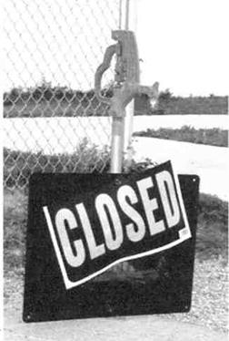 |
||||
The public water source in Westcliffe Town Park was closed during the drought of 2002. |
||||
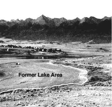 |
||||
Lake DeWeese shrank throughout the summer of 20002 as water discharge exceeded water inflow. |
||||
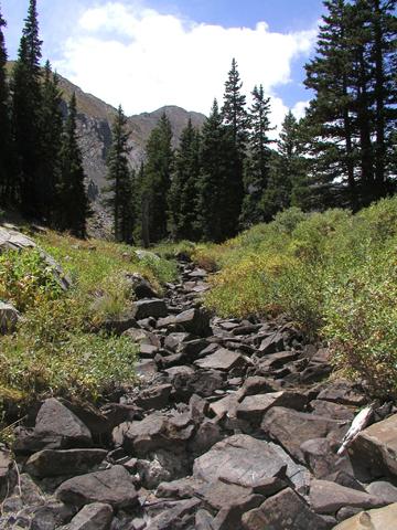 |
||||
Dry Creek in the Sangre de Cristo Mountains lived up to its name during late summer of 2002. It was dry, and so were many other creeks in the area. |
||||
All water used by Round Mountain District customers is from treated groundwater from wells. As of August 2002, RMD was pumping from three of its five wells. The wells in use ranged in depths from 80 feet to approximately 120 feet. All of the wells are reasonably shallow. Undoubtedly, there is additional ground water in deeper aquifers below the existing wells, but water rights issues come in to play there as well. In 2006, RMW placed a larger pump at its principal well, the Smith Well near Gape Creek. However, the new pump did not sufficiently improve the output of Smith Well. So RMD is currently investigating replacing the Smith Well with a new well, possibly as early as 2007. In addition, RMD needs to improve water pressure in parts of Silver Cliff and to add a new water tank east of Silver Cliff to provide for future development. As always, the availability of water is key to the area’s future. |
|
Landscape--Custer County, Colorado
Not many old timers who live here know how to tell the newcomers what it’s like, the local landscape I mean. Valley ranches with hayfields sprawling, bordered by clear rushing streams nourished by melt water from mountains up high. A land of many contrasts: a rock record of former seafloors and ancient alluvial fans, later heaved to the sky along mighty faults. Huge displacements that frame the landscape still. A land clad mostly with parched, gravely soils offers a challenge for the men and women who work it in faded jeans and old work shirts. But valley floors boast lush hay fields while thick stands of conifers adorn nearby mountain slopes. Inspecting the forests, however, reveals that all is not well. Boring beetles and munching bud worms work their way, even as I speak. Hungry insects don’t give a damn about forest ecology! Is this Nature’s plan?
Defunct shafts and old prospect pits in rocky terrain record hard-spent efforts by determined miners, eager to find their fortunes in silver and gold. An honest ledger documents more fortunes lost than won, I’m, sure. Truly, the industrious old timers love this land, and they’ve built an enduring record that proves it. But, the newcomers are smitten by this place as well. To show their affection, they’ve built dream homes and rustic retreats across the contours of the modern landscape: live-in trophies paid for by the sweat of their brows, but not from wealth won locally from this sun-splashed earth. Will the dreams of the new arrivers endure if their investments fail and their pensions run dry, like intermittent streams during periods of drought?
Today, Custer County is half-crazed with growth. Is that good or bad? About the future, ‘tis often said: “The answer, my friend, lies blowing in the wind.” For Custer County, I do believe: “The future, my friend, is riding on the water.”
(Wayne I. Anderson, 7-14-2000, with acknowledgment to James Hearst’s Landscape--Iowa.) |
||
References Barkmann, Peter, 2002. “Ground Water Resources in the Time of Drought.” Colorado Geological Survey, ROCKTALK, vol. 5, no. 4, p. 7-11 Drenner. Nora. 2006. “Round Mountain IDs three critical problems.” Wet Mountain Tribune, 9-14-2006. Gilluly, James, A. C. Waters, and A. O. Woodford. 1959. Principles of Geology, second edition, W. H. Freeman and Co., San Francisco, 534 p. Leet, L. D., and S. Judson. 1959. Physical Geology, second edition, Prentice-Hall, Englewood Cliffs, N. J., 502 p. Orsini-Meinhard, Kirsten. 2002. “Labor Day draws hordes to Lake Pueblo.” The Pueblo Chieftain, 9-03-2002. Piquette, Bud. 2002. (Mr. Piquette presented a program on Round Mountain District and local water issues on August 2002. He provided a typed copy of his notes used in the presentation. A summary of his talk appeared in Newsletter of the Sangre de Cristo Mountain Council, fall 2002. Topper, Ralf. 2002. “Ground Water in Colorado--A Primer”. Colorado Geology Survey, ROCKTALK, vol. 5, no. 4, p. 1-6. |
|
 |
 |
 |
||||