PONDERING THE DEEP PAST OF CUSTER COUNTY |
|
_________________________________________________________________________________ Imagine Colorado 250 million years ago. Rugged mountains existed, but not quite in the form we know today. At their base was an inland sea. Streams from the highlands brought down boulders, cobbles, sand, and silt and left alluvial fans and other erosional debris that later hardened into sandstone and conglomerate rocks. Much later, the present Rockies, including the Sangres, uplifted along faults. Volcanoes popped up; lava flowed across the land and layers of fiery ash accumulated. Still later, running water and alpine glaciers sculpted the modern landscape. ________________________________________________________________ By Wayne I. Anderson, Professor Emeritus (Geology), University of Northern Iowa, Cedar Falls, Iowa 50614. |
|
Custer County is home to some of the most beautiful mountain scenery found anywhere, and the foundation of that scenery is the county's geologic record. The most visible rock strata in the Sangres are from the Late Paleozoic (Pennsylvanian and Permian periods), which occurred 245 to 323 million years ago. The deposition, alteration, and uplift of these strata represent significant events in the local geologic history and of the geologic development of south-central Colorado overall. Geologists have discovered that Colorado in the Late Paleozoic was shaped by three main uplifts, which are included in what is known as the Ancestral Rocky Mountains. These highlands bordered a long depression called the central Colorado trough. (See figure.) At one time, this trough was filled with marine waters of an inland sea. Deposition of sediments along the flanks of the highlands and in the adjacent sea formed the Minturn Formation, which is conspicuous on Marble Mountain in the modern Sangres. Later, stream deposition formed the Sangre de Cristo Formation, which is quite prominent in today's mountain landscape. |
|
 |
||
Paleogeographic setting of the Ancestral Rocky Mountains (Apishipa, Front Range, and Uncompahgre uplifts) and the central Colorado trough in Middle Pennsylvanian to Early Permian time. The regional paleogeographic setting and the occurrences of copper in Middle Pennsylvanian to Lower Permian rocks are also shown. Adapted from Lindsey and Clark. 1995. |
||
_________________________________________________________________________________ Oxidized iron in the sedimentary rocks of the Sangre de Cristo Formation gives a reddish tint to the Sangre de Cristo Range and offers an explanation for the origin of their name. _________________________________________________________________________ |
|
The Minturn Formation formed in coastal areas at the base of the Ancestral Rocky Mountains and in an inland sea where marine waters submerged the central Colorado trough. Subsidence of the trough provided conditions for alluvial fans and deltas to prograde onto the sea floor during Middle Pennsylvanian time. Coarse alluvial and deltaic sediments and complex intertongued marine limestones and shales were the result. Such deposits occur interbedded within the Minturn Formation. Later, extensive erosion of the Ancestral Rockies produced huge alluvial fans. These deposits (Sangre de Cristo Formation) spread over the mixed marine-nonmarine sediments of the Minturn Formation. The lower part of the Sangre de Cristo Formation is composed primarily of sandstones, representing the distal (farthest from the source) part of alluvial fans. The upper part of the formation is dominated by coarse sandstones and conglomerates. Assigned to the Crestone Conglomerate Member, this coarse facies typifies the proximal (nearest to the source) part of alluvial fans. The Crestone Conglomerate is one of the most distinctive rocks in the Sangres, and the sizes of its clasts are impressive. Clasts as big as watermelons are common in the member in the Crestone area and in the upper reaches of South Colony Creek. Because of the presence of large, well-preserved clasts in the Crestone Conglomerate, it is possible to reconstruct the bedrock composition of the Ancestral Rockies with some certainty. Clasts in the conglomerate are indicative of an ancient mountain terrain composed of igneous rocks (including quartz monzonite and syenite, both somewhat similar to granite in appearance) and metamorphic rocks (commonly, the distinctly-banded rock called gneiss). It is interesting to note that these are rocks of Precambrian and Cambrian ages, both of which occur as bedrock in the Sangre de Cristos and surrounding areas. The Ancestral Rockies were made up of many of the same rocks that comprise today's deep bedrock, which is presently well exposed in the Wet Mountains. |
|
 |
||
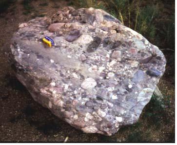
The Crestone Conglomerate is one of the most distinctive rock units in the Sangres. The size and composition of the clasts in the conglomerate help to determine its origin. These strata represent ancient alluvial fans, derived from Precambrian basement rocks. Film box on conglomerate boulder for scale. |
||
The Sangre de Cristo and Minturn formations dominate the skyline of the Sangre de Cristo Mountains in Custer County. For example, the Crestone Conglomerate Member is prominent on Crestone Needle, and limestone facies of the Minturn Formation are conspicuous on Marble Mountain. In addition, soluble limestones within the Minturn underwent dissolution to form several caves on Marble Mountain. Furthermore, blocks and fragments of the Sangre de Cristo and Minturn formations are common in glacial drift (till and outwash) at lower elevations along the flanks of the range. Oxidized iron in the sedimentary rocks of the Sangre de Cristo Formation gives a reddish tint to the formation and to the landscape overall and offers an explanation for the origin of the name of the mountain range. "Sangre de Cristo" is Spanish for "blood of Christ." Nearly all of the Sangre de Cristo Mountain peaks visible from the Wet Mountain Valley near Westcliffe are underlain by sedimentary strata of either the Sangre de Cristo or the Minturn formations, deposits of ancient coastal settings and seas. Consider the significance of this for a minute. The rocks that make up many of the highest peaks in the Sangres were once ancient coastal environments or former sea floors. Surely, some powerful geological forces have been at work here. What were these forces? When did the modern mountains uplift? We all know the Rockies are relatively young mountains, which explains their proverbial ruggedness. The most recent era in geologic time is the Cenozoic, which started about 65 million years ago. It was during this era that the Colorado Sangre de Cristos rose as a huge fault block. The Wet Mountain Valley, an intermontane graben (a large down-dropped block) bordered by the Sangre de Cristo Mountains on the west and the Wet Mountains on the east, came into existence in Mid-Cenozoic time. The graben is bounded on the west by the Alvarado Fault system (see figure) which behaved as a normal fault in Cenozoic time, producing displacements of more than 6,700 feet. Vertical displacements on the east side of the Wet Mountain Valley graben are less, measuring about 1,200 feet near the town of Westcliffe. The Westcliffe Fault marks the eastern boundary of the graben and brings Precambrian igneous and metamorphic rocks in contact with Cenozoic (Tertiary) valley-fill sediments. The valley-fill materials are poorly exposed but consist primarily of interlayered gravel, sand, silt, clay, and volcanics. |
|
 |
||
In Custer County and vicinity, the major fault zones not only determined the size, shape, and location of the mountains and adjacent basins, they probably also influenced the emplacement and location of Tertiary igneous rocks. Volcanic rocks of Oligocene and Miocene ages crop out along the margin of the Wet Mountain graben in several places. Examples include sheet-like exposures of volcanic rocks on the west side of the Wet Mountain Valley in the Grape Creek area and near Goat Creek. Small volcanic fields with a variety of Tertiary igneous rocks occur on the east side of the Wet Mountain Valley near Silver Cliff, Rosita, and Deer Peak. Igneous activity included extrusions of fiery lava, avalanches of incandescent ash and other ejecta, flows of scalding hot mud-ash mixtures, and emplacement of shallow intrusives. Metallic mineralization, including silver and gold, was associated with the volcanic activity near the Silver Cliff and Rosita mining districts. These metals were apparently transported by hot vapors and fluids associated with the Tertiary igneous activity. |
|
_________________________________________________________________________ Igneous activity included extrusions of fiery lava, avalanches of incandescent ash and other ejecta, flows of scalding hot mud-ash mixtures, and emplacement of shallow intrusives. _________________________________________________________________________ |
|
Greenhorn Mountain, the highest point in the Wet Mountains, is located a few miles southeast of Custer County; it is capped with Tertiary volcanic rocks. Tertiary volcanics also crop out in the northern Wet Mountain Valley near Hillside, Oak Creek, and Little Cottonwood Creek. Perlite, a volcanic glass, has been quarried near Silver Cliff. Perlite has the composition of rhyolite (the fine-grained equivalent of granite) and a higher water content than obsidian. It displays a glassy, cracked texture, indicative of rapid cooling and contraction. A prominent exposure of white-to-light gray Tertiary volcanic ash crops out between Johnson and Four Mile gulches, about five miles northeast of Westcliffe. In addition, younger volcanic ashes have been discovered in two gravel pits in Custer County. Assigned to the well known and widespread Pearlette ash falls of Pleistocene age, these deposits probably came from distant volcanic sources in the vicinity of Yellowstone National Park. The last chapter of Custer County's geologic transformation can be interpreted from the Quaternary record, approximately the last two million years of geologic time. Included within this record are episodes of glaciation and deglaciation in the Sangres during the Pleistocene Ice Age. Geologic quadrangle maps for the east flank of the Sangres show three separate glacial tills. The valleys on the east side of the Sangres were filled by glaciers that extended out into the Wet Mountain Valley. J. J. Stevenson commented on this in 1881: "The eastern slope of the Sangre de Cristo Mountains is literally gashed to the central line by universal glacial gorges which are closed by enormous moraines extending hundreds of feet into the valley." |
|
 |
||
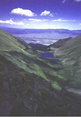
Comanche Lake is representative of the numerous glacial lakes in the high country of the Sangres. This view is from the crest of the range, looking northeastward toward the Wet Mountain Valley and the Wet Mountains. Although the Sangre de Cristo Mountains were glaciated extensively during the Pleistocene Ice Age, the lower-elevation Wet Mountains escaped glaciation. |
||
References Anderson, Wayne I. 2001. Geology of the Custer County Area, South-Central Colorado. Unpublished Manuscript, 53 p., Department of Earth Science, University of Northern Iowa, Cedar Falls, Iowa. Lindsey, D. A. 1986. Log for Joint SEPM-Colorado Scientific Society Field Trip from Westcliffe to Crestone, Colorado, September 20-21, 1986: Late Paleozoic Sedimentation and Laramide Tectonics of the Sangre de Cristo Range. Open-File Report 86-452. U. S. Geological Survey. Lindsey, D. A., P.A.M. Andriessen, and B. R. Wardlaw. 1986. "Heating, Cooling, and Uplift during Tertiary Time, Northern Sangre de Cristo Range, Colorado." Geological Society of America Bulletin 97:1133-1143. Lindsey, D. A., and R. F. Clark. 1995. Copper and Uranium in Pennsylvanian and Permian Sedimentary Rocks, Northern Sangre de Cristo Range, Colorado. U. S. Geological Survey Bulletin 2116.
Based on an article originally published in SMC Newsletter, Spring 1999 |
|
 |
 |
 |
||||