An Introduction to the Geology of the Custer County Area South-Central Colorado by Wayne I. Anderson, Professor Emeritus (Geology) Department of Earth Science University of Northern Iowa Cedar Falls, Iowa 50614 Updated 2006 |
||
Introduction |
||
 |
||
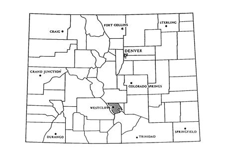
Custer County (fig. 1) is located in south-central Colorado, bordered by Pueblo County on the east, Fremont County on the north, Saguache County on the west, and Huerfano County on the south. The Promontory Divide marks the boundary between Custer and Huerfano counties and also divides the Wet Mountain Valley on the north from Huerfano Park to the south. The San Isabel National Forest encompasses substantial areas of eastern and western Custer County. |
|
 |
||
Figure 1. Location of Custer County, Colorado and its county seat, Westcliffe. Slanted pattern depicts area of the county soil survey. Areas without pattern are within the San Isabel National Forest. From McCullough et al., 1982, Soil Survey of Custer County Area, Colorado. |
||
Custer County boasts some of the most beautiful mountain scenery found anywhere. The foundation of that scenery is the county's geologic record, a record that includes a variety of rocks and sediments. Rocks make up the essential part of the Earth's crust and preserve clues that enable geologists to interpret the geological past of our planet. Although rocks form in a variety of ways, they generally are classified into three major groups or families: igneous, sedimentary, and metamorphic. Custer County has all three. Igneous rocks, named for the Latin word for fire, solidify from hot molten silicate material called magma. When magma cools slowly below the Earth's surface, coarsely crystalline rocks like granites form. When magma reaches the Earth's surface, it is termed lava. Lava generally cools quickly and produces finely crystalline rocks such as basalt. Extremely rapid cooling produces volcanic ash, pumice, scoria, or glass. The rock record of Custer County reveals both intrusive igneous rocks formed at depth and extrusive igneous rocks formed at the surface. In addition, volcanic ash and other ejecta are found locally. The historically-significant metallic deposits of the county were produced by igneous processes. Sedimentary rocks are composed of grains or fragments of preexisting rocks, chemical precipitates, or organic remains. The materials composing sedimentary rocks have usually been transported by agents such as running water or marine currents. Common sites for accumulation of sedimentary rocks include river channels, alluvial fans, coastal lowlands, sand dunes, deltas, lakes, and seas. Fossils are often associated with sedimentary rocks, and they provide key information about depositional environments. Custer County has an intriguing record of sedimentary rocks and sediments. The deposits reveal ancient settings such as alluvial fans, stream channels, deltas, sand dunes, glacial moraines and outwash plains, and both shallow and deep marine seafloors. Metamorphic rocks are products of transformation, generally by heat and pressure. Reactions with fluids and gases also alter rocks. During metamorphism, the original character of the parent rock is obliterated and its composition is modified to form new minerals which are stable at higher temperatures and pressures. In Custer County, metamorphic rocks are abundant in both the Wet Mountains and the Sangre de Cristo Range. The roadcuts along Highway 96 through Hardscrabble Canyon display an interesting and accessible array of metamorphic rocks, including banded rocks called gneisses and mica-rich schists. |
||
Geologic Time |
||
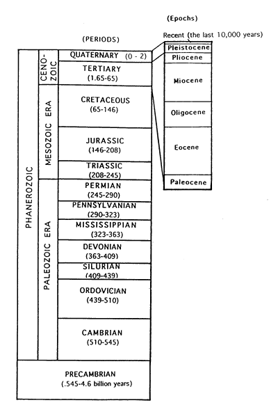
The oldest bedrock in the Custer County area is of Precambrian age (fig. 2), nearly two billion years old. The Precambrian is generally divided into two divisions: Archean (older than 2.5 billion years ago) and Proterozoic (.545 to 2.5 billion years old). All of Custer County's Precambrian record is assigned to the Proterozoic. Late Paleozoic sedimentary rocks, approximately 290 to 245 million years old, are conspicuous in the high country of the Sangres. Mesozoic strata, roughly 200 to 65 million years old are exposed near Wetmore in eastern Custer County. The Cenozoic Era of geologic time, essentially the last 65 million years, is divided into the Tertiary and Quaternary periods. Custer County's Tertiary record includes a variety of volcanic rocks and basin-fill sediments. The local Quaternary record consists of glacial till and outwash and an assortment of fluvial (stream and related processes) deposits. The magnitude of geologic time (fig. 2) is so great that it is difficult for humans to comprehend. Geologic time is measured in millions of years rather than by hours, days, weeks, months, years, and centuries to which humans are accustomed. The dimension of geologic time can be understood better if we compare the geologic time scale (4.6 billion years ago to present time) to a calendar year (365 days). If geologic time were scaled on the basis of a calendar year, most of the year (January 1-mid November) would be represented by Precambrian time (about 4 billion years in duration). Paleozoic rocks (545-245 million years old) would have accumulated during about one month (mid-November to mid- December). Mesozoic time (The Age of Reptiles, 245-65 million years ago) would be represented by two weeks (December 13-December 27), and Cenozoic time (The Age of Mammals, the last 65 million years of geologic time) would consist of the last five days of the calendar year. The Pleistocene Ice Age (approximately 2 million years ago to 10,000 years ago) would be represented by a few hours. The portion of the geologic time scale assigned to the Holocene (Recent) Epoch is but a minute of the calendar year. |
||
 |
||
Figure 2. The geologic time scale. The numbers represent the ages of periods in millions of years. The Quaternary Period consists of the last 2 million years of geologic time and is represented by the Pleistocene and Holocene (Recent). The Recent consists of approximately the last 10,000 years, a dimension too small to plot to scale on this diagram. The Precambrian is commonly divided into the Proterozoic and Archean eons, spans the interval of geologic time from .545 to 4.6 billion years ago. The Custer County area has an excellent geologic record of Proterozoic igneous and metamorphic rocks, but no Archean record. Cambrian intrusives occur in the county, and a record of Pennnsylvanian and Permian strata is well displayed. Tertiary volcanic rocks and basin-fill sediments and Quaternary fluvial and glacial deposits are also well known. A partial record of Lower and Middle Paleozoic strata occurs along the western flank of the Sangres and in the eastern Wet Mountains. Mesozoic strata outcrop in eastern Custer County near Wetmore. Information for this figure compiled from multiple sources. |
||
The Geological Setting of Custer County, Colorado |
||
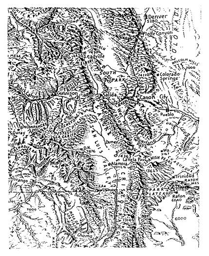
The Sangre de Cristo Range, the Wet Mountain Valley, and the Wet Mountains (fig. 3) are dominant geologic features in the Custer County area. The county is part of the Southern Rocky Mountain Province, a region consisting primarily of north-south mountain ranges with cores of Precambrian igneous and metamorphic rocks. The mountains are usually flanked by inclined sedimentary strata of Paleozoic and Mesozoic ages. |
|
 |
||
Figure 3. A landforms map of part of the Southern Rocky Mountain region. Note the location of the Sangre de Cristo Range, the Wet Mountain Valley, and the Wet Mountains. Adapted from Raisz,1957, Landforms of the United States, Sixth Revised Edition. |
||
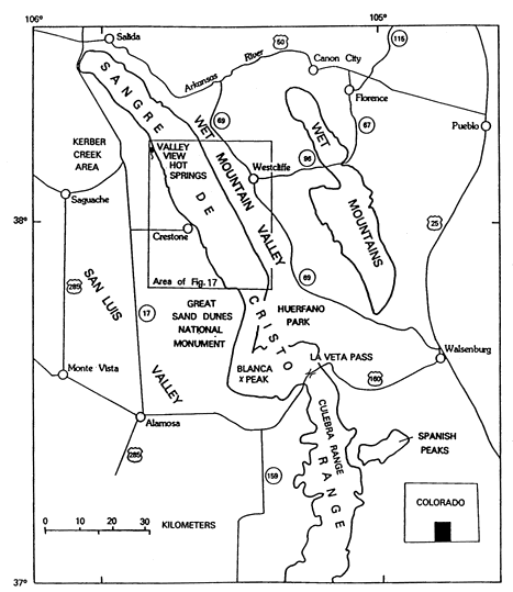
The Sangre de Cristo Range extends from the Arkansas River valley near Salida for nearly 150 miles to just beyond Santa Fe, New Mexico (fig. 4). Some geologists apply the name Culebra Range to the segment of the range that extends south from La Veta Pass in southern Colorado into New Mexico. |
|
 |
||
Figure 4. An index map showing features of south-central Colorado. Some geologists apply the name Culebra Range to the segment of the Sangre de Cristo Range located south of La Veta Pass. From Lindsey, 1986. |
||
The Sangre de Cristo Range, originally considered to be a large anticlinal structure (upfolded region), is now known to be more complex. The structure of the Sangres is complicated by low-angle faults that functioned as thrust faults during Laramide deformation when the Rocky Mountains were laterally compressed during Late Mesozoic to Early Tertiary time. Later in the Cenozoic (mid-Tertiary), the bordering fault systems of the Sangres were reactivated, and the range was uplifted as a block (horst). The San Luis Valley to the west of the Sangres and the Wet Mountain Valley to the east formed where large blocks (grabens) dropped downward along faults. The Wet Mountains underwent uplift along flanking fault systems too. The Wet Mountain Valley, a high-elevation intermontane basin, is similar to the larger South (fig. 3), Middle, and North Parks located north of the Arkansas River. The name "park" is also applied to the intermontane region (Huerfano Park) located between the Sangres and Wet Mountains in Huerfano County (fig. 3) . The Wet Mountains flank the Wet Mountain Valley on the east. Sedimentary strata have been eroded from the crest of the mountains, exposing Precambrian igneous and metamorphic rocks which dominate the present landscape of the Wet Mountains. |
|
References Lindsey, D. A. 1986. Log for Joint SEPM-Colorado Scientific Society Field Trip from Westcliffe to Crestone, Colorado, September 20-21, 1986: Late Paleozoic Sedimentation and Laramide Tectonics of the Sangre de Cristo Range. Open File Report 86-452. U.S. Geological Survey. Lindsey, D. A., P.A.M. Andriessen, and B. R. Wardlaw. 1986. "Heating, Cooling, and Uplift during Tertiary Time, Northern Sangre de Cristo Range, Colorado." Geological Society of America Bulletin 97:1133-1143. |
|
 |
 |
 |
||||