Hot Time in the Valley |
||
Wayne I. Anderson |
||
Back in Tertiary time, during geologic way-back-when, volcanism reshaped the local landscape, time and time again.
Vents near Silver Cliff and Rosita burst forth in a fiery glow ejecting volcanic debris and spewing forth many a lava flow.
With the passage of time, the volcanoes died and their rocks grew cold, but they still ignited the imaginations of miners, seeking riches of silver and gold. |
|
 |
|||
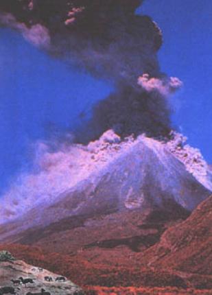
The ancient Wet Mountain Valley probably looked something like this some 30 million years ago. Flows of fiery lava, ejections of incandescent ash, and quickly-cooled volcanic glasses left their signatures in the rocks that make up the plateaus and hills near Silver Cliff. These events took place long before humans were on Earth, but a few prehistoric mammals probably viewed the volcanic fireworks going on in the Wet Mountain Valley during Middle Tertiary time. Reconstruction based on a modern ash eruption in New Zealand from an image of the Macmillan Publishing Company and from a Mid-Tertiary diorama at the Denver Museum of Natural History. |
|||
Tertiary Igneous Activity |
||
Volcanic rocks of Tertiary age, approximately 30 million years old, crop out along the flanks of the Wet Mountain Valley in several places. Examples include sheet-like exposures of volcanics on the west side of the Valley in the Grape Creek area and near Goat Creek. The eruptive vent for the volcanic rocks along Grape Creek, approximately 12 miles south of Westcliffe, is unknown. Possibly, these brown-to maroon mudflows of volcanic ejecta came from an eruptive center west of the present outcrops. Volcanic fields occur on the east side of the Wet Mountain Valley near Silver Cliff, Rosita, and Deer Peak. In addition, Tertiary volcanic rocks crop out in the northern part of the Valley, near Hillside, Oak Creek, and Little Cottonwood Creek. Greenhorn Mountain, the highest point in the Wet Mountains, located just a few miles southeast of Custer County, is capped with ancient andesitic lava flows. The Tertiary igneous rock of the Wet Mountain Valley have been assigned to seven mappable units by Scott and Taylor (1975). The thick alluvial sediments that fill the Wet Mountain Valley are mixed with volcanic materials. The composition of basin fill changed markedly with the onset of volcanism along the flanks of the Valley. Sedimentary deposits gave way to mixtures of lava flows, volcanic ash deposits, ash flows, lahars (mudflows of volcanic ejecta), and stream-laid sediments with abundant volcanic debris. The Devils Hole Formation is a sedimentary unit with abundant volcanic material, probably derived from eruptions at the Rosita Volcanic Center. The Deer Peak Volcanics are composed of materials that spread southward and westward from a volcano located in the Wet Mountains along Ophir Creek, east of Deer Peak. Volcanic fields surround both the Rosita and the Silver Cliff Volcanic centers. A variety of volcanic rocks were derived from these centers, including extrusive flows, volcanic glasses, and tuffs (consolidated ash and other volcanic ejecta). |
|
 |
||
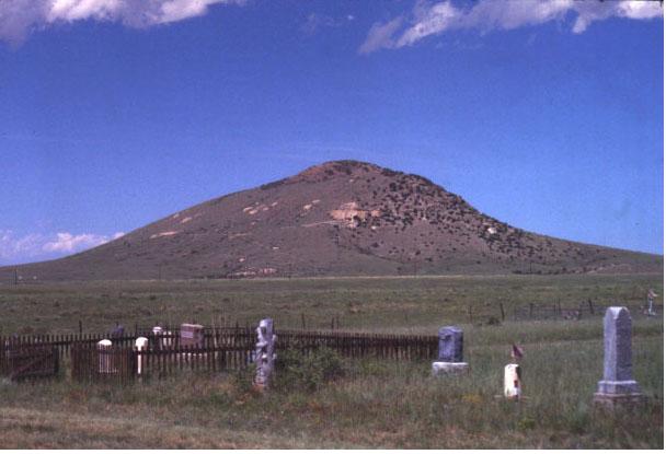
Round Mountain, a product of Tertiary volcanism from the Silver Cliff Volcanic Center, is a prominent landmark today. The rocks that compose Round Mountain are primarily rhyolite lava flows with some associated indurated ashes (tuffs). In addition, volcanic glasses occur in the area. View of Round Mountain taken from the Silver Cliff Cemetery, looking to the northeast. |
||
Perlite, a volcanic glass with a higher water content than obsidian, has been quarried near Silver Cliff. It displays a glassy texture like obsidian, indicating very rapid cooling. Perlite has a chemical composition similar to rhyolite, a fine-grained rock of granitic composition. Prominent exposures of white-to-light gray volcanic ash occur between Johnson and Fourmile gulches, about five miles northeast of Westcliffe. Some of the ash layers are thinly-laminated, suggesting deposition in standing water. According to Scott and Taylor (1975), these deposits closely resemble lake-deposited ash beds, like those at Florissant Fossil Beds National Monument in Teller County, Colorado. During the late stages of volcanic activity, mineral-bearing waters and gases deposited an array of metals in the local Tertiary bedrock. Included in the deposits were ores of silver, gold, lead, copper, and zinc. |
|
 |
||||
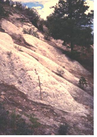
Tuff (indurated volcanic ash) is visible today in the Goat Creek area, along the east flank of the Sangres, and also between Johnson and Fourmile gulches, northeast of Silver Cliff. Photo taken in the Goat Creek area with geologic hammer for scale. |
||||
References Scott, G. R., and R. B. Taylor. 1975. Post-Paleocene Tertiary Rocks and Quaternary Ash of the Wet Mountain Valley, Colorado. U. S. Geological Survey Professional Paper 868. Sharp, W.N. 1978. Geologic Map of the Silver Cliff and Rosita Volcanic Centers, Custer County, Colorado. U.S. Geological Survey Miscellaneous Investigations Series Map I-1081. |
|
 |
 |
 |
||||