Traverse Along South Hardscrabble Creek: A Trip Through Time |
|
Wayne I. Anderson |
|
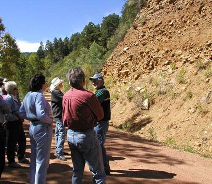
Previous articles in this series focussed on the geology of the Sangre de Cristo Range, but the geological history of the Wet Mountains is equally interesting. In addition, several public roads provide easy access to examine rock exposures in road cuts. There are spectacular exposures of Precambrian rocks in Hardscrabble Canyon, along Highway 96. However, because of relatively-heavy traffic through the canyon, I do not recommend examining these exposures if you are with a group. Similar rocks can be conveniently examined in exposures along Forest Road 386. Study of this rock sequence contributes greatly to an understanding of the area's geological past. To reach Forest Road 386, drive approximately 5 miles south on Highway 165 from its junction with Highway 96 at McKenzie Junction. Precambrian bedrock makes up the bulk of the Wet Mountains and its fractured and weathered rock serves as an important aquifer. The oldest Precambrian bedrock consists primarily of banded metamorphic rocks (gneisses) and igneous intrusions. Gneiss forms the core of the Wet Mountains and is at least 1.7 billion years old. Much of the gneiss terrain in the Wet Mountains is described as migmatitic gneiss (composite rocks with both igneous and metamorphic components or appearances). These gneisses probably formed by metamorphism of ancient sedimentary strata and layered volcanics. Granite-like igneous rocks, approximately 1.4 billion years old, intrude gneisses in exposures along the valley of South Hardscrabble Creek. Formerly called "San Isabel Granite", these granite-like intrusives, are now classified as quartz monzonite, a close relative of granite. These intrusive bodies solidified from slow-cooling magma, deep below the Earth's surface. |
|
 |
||||
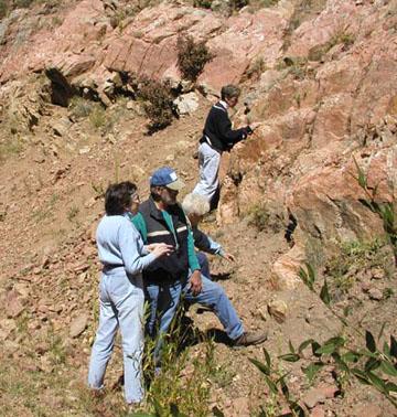
Geology enthusiasts examine exposures of "San Isabel Granite" along South Hardscrabble Canyon. These rocks are approximately 1.4 billion years old. |
||||
As you traverse along Road 386 from west to east along the east flank of the Wet Mountains, progressively younger rocks come into view. Paleozoic sedimentary rocks are in fault contact here with Precambrian igneous and metamorphic rocks. Both Paleozoic and Mesozoic strata were deformed and uplifted as part of the mountain building that produced the modern Rocky Mountain system in Late Mesozoic-Early Cenozoic time. |
|
 |
||
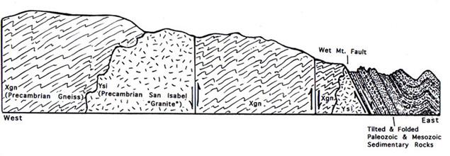
A Cross-Sectional Diagram Showing Structural Relationships Along South Hardscrabble Canyon, East Flank of Wet Mountains. Not to Scale. |
||
The oldest Paleozoic strata in the area are poorly-exposed marine beds, assigned tentatively to Lower and Middle Paleozoic systems. The Late Paleozoic (Pennsylvanian and Permian) Fountain Formation is better exposed. This formation is a lateral equivalent of the Sangre de Cristo Formation, a rock unit that is conspicuous in the Sangre de Cristo Range. The Fountain Formation is nonmarine and largely deposits of ancient streams and alluvial fans. The Fountain Formation forms prominent "flatiron" ridges near Boulder and elsewhere in Colorado. |
|
 |
||
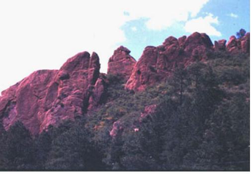
The Fountain Formation adds color to the landscape along the east flank of the Wet Mountains near Beulah, Colorado. |
||
Mesozoic rock formations exposed along Road 386 include, from oldest to youngest: the Entrada Sandstone, Morrison and Ralston Creek formations (Jurassic), and the Purgatoire Formation and Dakota Sandstone (Cretaceous). The Entrada Sandstone formed by wind deposition and is well displayed in Arches National Monument, Utah. The Morrison and Ralston Creek formations are largely nonmarine. The Morrison Formation is well known for bearing dinosaur remains, including important fossils near Canyon City. The Purgatoire Formation and the Dakota Sandstone were deposited in mixed marine and nonmarine settings, in and adjacent to a large inland sea. Resistant sandstones of these units form prominent linear ridges called hogbacks. The Dakota Hogback is a conspicuous landform in the Wetmore area and elsewhere in Colorado. |
|
 |
||||
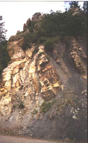
Steeply-inclined, resistant sandstones of the Purgatorie and Dakota formations form a conspicuous hogback along the east flank of the Wet Mountains. |
||||
Look for slickensides in rocks throughout the exposures along Road 386. Slickensides are polished and striated surfaces, produced by friction along fault planes. Faulting is prevalent along the east flank of the Wet Mountains. Also, note deposits of very-coarse, boulder-bearing alluvium, situated well above the current level of South Hardscrabble Creek. These gravel and boulder-bearing deposits are the products of Ice-Age steams. For example, the Quaternary Broadway Alluvium is 10-20 feet thick and lies on terraces, about 30-40 feet above South Hardscrabble Creek. |
|
 |
||
A geology group discusses the origin of the Quaternary Broadway Alluvium, South Hardscrabble Canyon. |
||
References Noblett, J. B. 1987. "Geology of the Precambrian Metamorphic Rocks along South Hardscrabble Creek." The Mountain Geologist, volume 24, pages 67-76. Taylor, R. B. and G. R. Scott. 1973. Reconnaissance Geologic Map of the Wetmore Quadrangle, Custer and Pueblo Counties, Colorado. Miscellaneous Field Studies Map MF-548. U.S. Geological Survey. |
|
 |
 |
 |
||||