A Spectacular Boulder Field |
||||
Near the Head of Texas Creek Drainage |
||||
Wayne I. Anderson |
||
Yielding to gravity, slabs of bedrock slid and tumbled. Down the slopes, giant rocks crashed and rumbled. The boulders above Texas Creek now seem out of place, detached from their home high on the mountain face. |
||
O'Hanlon (1999) describes the Texas Creek Boulder Field as one of the most interesting boulder fields in the Sangre de Cristo Range and indicates that overall the feature gives the impression of moonscape. His excellent trail guide provides information on how to reach the site. Thomason and Porter (1997) illustrate a portion of the impressive boulder field at 11,500 feet, high in the Texas Creek drainage. Intrigued by these accounts, Jan and I hiked up to the boulder field in September of 2001 to take a look. The Texas Creek Boulder Field is a fine example of landslide topography. In geologic usage, landslide refers to a moderately rapid to rapid movement of earth material such as downward sliding or falling of a mass of rock, weathered material, or a mixture of the two. Five types of landslides are commonly recognized: slumps, debris slides, debris falls, rock slides, and rock falls. |
|
 |
||
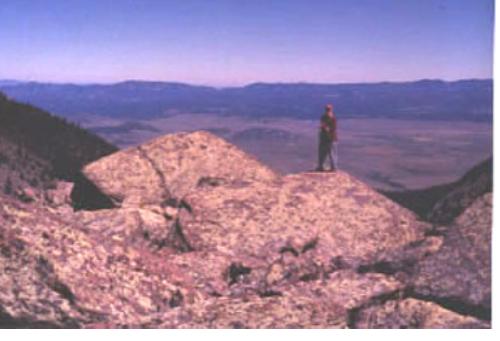
Cabin-size boulders are common in the spectacular Texas Creek Boulder Field on the east flank of the Sangre de Cristo Range, northwest of Westcliffe, Colorado. Composed of sandstone and conglomerate, the huge boulders represent rock falls and rock slide events, during the last 50,000 years of earth history. Geologist on sandstone boulder provides scale; photo taken looking eastward toward the Wet Mountains, September of 2001. Rock falls and rock slides are the dominant types of landslide features in the upper Texas Creek area, where huge blocks of sandstone and conglomerate have slid and tumbled downslope. The blocks were derived from nearby exposures of Late Paleozoic Sangre de Cristo Formation. A landslide scar is visible near the head of the valley, indicating where some of the blocks were derived from the local bedrock. Contributing factors that promote landslides are present at the head of the Texas Creek Drainage, namely: inclined bedding that slants 25 to 30 degrees downslope, steep topography, and a source of moisture from snow melt to saturate rock masses and lubricate bedding planes and fractures within the bedrock. Lindsey, Soulliere, and Hafner (1985) prepared a geologic map of Electric Peak and southwestern part of Beckwith Mountain Quadrangle. Their map shows a half-mile wide area of Quaternary Rock Fall Deposits (Qrf) between 11,500 and 11,800 feet at the head of Texas Creek. This is the area of the spectacular Texas Creek Boulder Field. Qrf deposits are described in the map legend as Holocene and Late Pleistocene in age (approximately the last 50,000 years of earth history); they include loose blocks of talus on steep slopes. The unit mapped as Quaternary Rock Fall Deposits likely represents some ancient rock slides, in addition to the rock fall deposits. Take a hike up Texas Creek and see what you think! |
|
 |
|
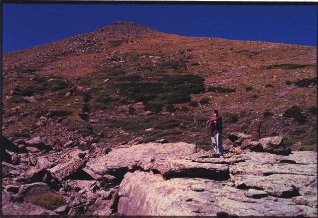
Looking westward from the Texas Creek Boulder Field, one can see inclined beds of sandstone and conglomerate. The angular boulders of the Texas Creek Boulder Field were derived from nearby Late Paleozoic bedrock and tumbled and slid downslope under the influence of gravity. Geologist in foreground for scale. |
||
References Lindsey, D. A., S. J. Soulliere, and K. Hafner. 1985. Geologic Map of Electric Peak and Southwestern Part of Beckwith Mountain Quadrangles, Custer and Saguache Counties, Colorado. Miscellaneous Field Studies Map MF-1786. U. S. Geological Survey. O'Hanlon, Michael. 1999. The Colorado Sangre de Cristo: A Complete Trail Guide, 3rd edition, Hungry Gulch Press, Westcliffe, Colorado, 71 p. Thomason, Bob, and Mary Jean Porter. 1997. Sangre de Cristo Wilderness: A Territory of the Heart. Music Mountain Press, Westcliffe. Colorado, 48 p. |
|
 |
 |
 |
||||